Newly discovered crushing circle on Totley Moss
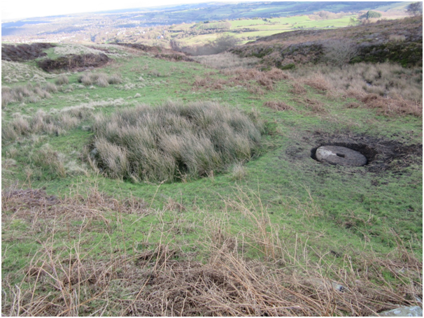
A partially buried, vegetation covered ‘millstone’ was reported by the grazier located in an enclosure of grassland, rush and bracken at grid reference SK2908979659. The enclosure, which is managed by the Eastern Moors Partnership, lies to the south of Moss Road and the previously unrecorded stone is in its SW corner on level ground at the edge of a circular, reed-filled pond (Fig.1). As there is no evidence that millstones were ever produced in this locality it was decided to obtain SSSI consent for the removal of turf and soil in order to examine the features of this particular stone and hence determine a possible reason for it being in its present position.
Excavation (Fig.2) revealed a circular piece of gritstone 1.40 metres in diameter with a square, central hole 0.24 metres by 0.24 metres. The thickness varied from 0.18metres at the edge to 0.24 metres at the centre. The upper, visible surface appeared flat and so the hidden surface underneath was assumed to be slightly domed. The large central hole (Fig.3), which would have been suitable to hold a substantial timber axle of square cross-section, is typical of a crushing stone of which there are several examples used to crush lead ore throughout the lead mining areas of the Peak District. The flat edge of the stone (Fig.4) showed evidence of wear which could have occurred as it was rolled in a vertical plane during the crushing process. The edge showed no evidence of having packing slots cut into it which suggested that it was not fitted with an iron tyre as are many crushing stones at lead mining sites.
On examining an historic Ordnance Survey map of 1877 it could be seen that the stone’s present position lies at the edge of dashed circle of about 8 metres diameter with a dot in the centre. This feature may be interpreted as a crushing circle within the working area associated with a pair of rectangular structures, labelled as brick kilns, only 20 metres to the East (Fig.5). A track from Moss Road to the working area is shown to continue across the small stream to the South of the site and head directly to the original, 19th Century location of the well known Totley Firebrick Works approximately 700 metres to the South East. These features were still recorded on maps in the 1880s but by 1898 both the brick kilns and the circular feature had disappeared from the O.S. map leaving only the track and a slightly smaller circular pond which is still in existence today.
This reed-filled circular pond, 5.20 metres in diameter, was found to be stone lined and of a uniform depth of about 0.35 metres. It was surrounded by a roughly circular area of level ground (Fig.6).
Further inspection of the site revealed the locations of the brick kilns and inspection of the collapsed boundary walls produced numerous firebricks and pieces of kiln lining. The remains of a possible leat to convey water from the nearby stream to the working area were identified just beyond the Western edge of the enclosure.
The site lies close to the extensive remains of mining for coal, ganister and fireclay (Barnatt, J. 2011). Ganister is a type of hard sandstone of high silica content which is used in the manufacture of refractory bricks for which there would have been a ready market for furnace linings in the Sheffield area. The manufacturing process (Battye, R. 1997) involves crushing, grinding and moistening the ganister rock, binding by adding a small amount of lime and then putting into moulds which are allowed to dry before firing in a coal-fired kiln for 3-4 days.
The present site may possibly be interpreted as having been used for the manufacture of silica firebricks on a fairly small scale at the latter end of the 19th Century. It is probable, therefore, that the stone is part of a horse-powered crushing circle used to crush the ganister rock. A large timber axle, pivoted at the centre of the circle, would have passed through the square central hole of the vertical crushing stone and was then attached to a horse which was led around a circular track. It is possible that the present day circular pond is in fact the remains of a crushing pit into which the ganister rock was placed and around which the crushing stone travelled.
Survey and possible excavation of the features of the working area may provide further evidence of the processes carried out and the products manufactured at this small firebrick works.
Stuart Nunn 2016.
.

Fig.1
Map showing the location of the possible crushing stone.
SK 29089 79659
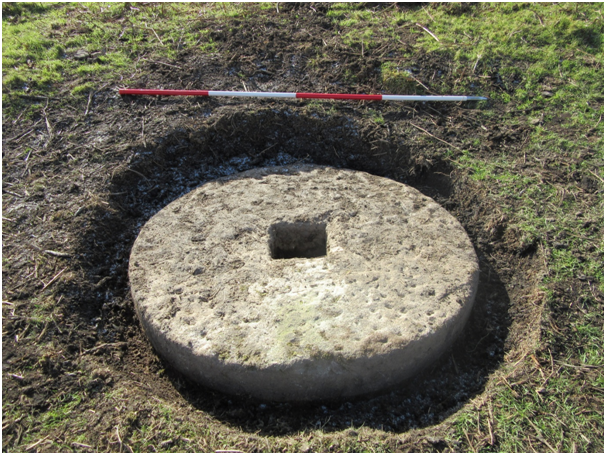
Fig.2
Excavated crushing stone
Scale 2 metres
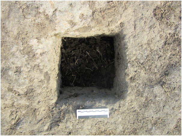
Fig.3
Central square axle hole.
Scale 10cm

Fig.4
The edge of the crushing stone shows signs of wear as would be expected if used to crush ganister rock without an iron tyre in place.

Fig.5
Detail from Ordnance Survey Map of 1877.
The symbol representing a crushing circle is located at the present location of the small pond and excavated stone.
The track from Moss Road follows the most convenient route to access the working area.

Fig.6
The site of the possible crushing circle looking East across the working area towards the location of the former brick kilns.
References
Barnatt, J. 2011. Peak District Mines – Observations and Discoveries – Part 36: Mining between Owler Bar and Totley. PDMHS Newsletter 137.
Battye, R. 1997. A Study of the Ganister Industry –of Sheffield from the Mid-19th to the Mid-20th Century. University of Sheffield (MA Thesis).
Thanks for help and advice to –
John Barnatt, Richard Carr, Nick Denniff, Rachael Hall, Stella Maguire, Paul Smith and Kim Strawbridge.